Cyclone Alfred is bearing down. Here’s how it grew so fierce – and where it’s expected to hit
The seas off southeast Queensland are unusually warm, helping Cyclone Alfred intensify as it barrels towards the coast.
Steve Turton, Adjunct Professor of Environmental Geography, CQUniversity Australia
6 March 2025
Tropical Cyclone Alfred is strengthening as it bears down on the coast of southern Queensland and northern New South Wales, prompting fears it may become a destructive category 3 cyclone before it makes landfall.
As of Wednesday, the cyclone was a category 2 and had begun moving west towards land. It is forecast to maintain intensity on Thursday and cross the coast early on Friday morning, probably between Maroochydore and Coolangatta.
According to the Bureau of Meteorology, the possibility of the system reaching a low-end category 3 was a low risk but “cannot be ruled out”.
The bureau has issued warnings from Double Island Point in Queensland to Grafton in NSW. The area includes Brisbane, the Gold Coast, the Sunshine Coast, Byron Bay and Ballina.
Brisbane Lord Mayor Adrian Schrinner says modelling shows 20,000 properties in Brisbane could be affected by storm surge or flooding.
The intensifying cyclone is a major concern, and makes Cyclone Alfred an unusual phenomenon. Cyclones typically lose strength as they approach the coast – especially this far south. It means Alfred may cause extensive damage, including to inland areas. We can expect it to last well into Friday before petering out and heading south on Saturday.
From Wednesday afternoon and into Thursday, the bureau forecasts gales, with damaging wind gusts to 120km an hour, along the coast from southeast Queensland to northeast NSW.
From Thursday afternoon, destructive wind gusts of up to 155km an hour may develop around the coast and islands as Alfred’s “destructive core” approaches and crosses the coast, the bureau says.
If Alfred crosses the coast on Friday morning during high tide, it may cause a dangerous storm surge along the coast, especially in waterfront suburbs near and south of the cyclone’s centre. This may inundate low-lying areas, such as canal communities of the Gold Coast.
In Brisbane, peak storm surges are expected from Thursday onwards. Some 20,000 properties have been warned of impacts ranging from minor inundation in yards to significant flooding inside homes. Areas most at risk include Nudgee Beach, Brighton, Windsor, Ashgrove, Morningside and Rocklea.
Close ups of areas most at risk:
Damaging surf may also cause serious erosion at open beaches between Sandy Cape and Grafton, and further south into NSW.
From Thursday, residents in southeastern Queensland and northeastern NSW have been told to expect heavy to intense rain. It may lead to life-threatening flash flooding – again, near and south of the cyclone centre.
Northern NSW has already been hit by devastating flooding in recent years, most recently in February 2022. Many of its settlements, including Lismore, are along or close to major river courses. Residents are understandably anxious about what the next few days may bring.
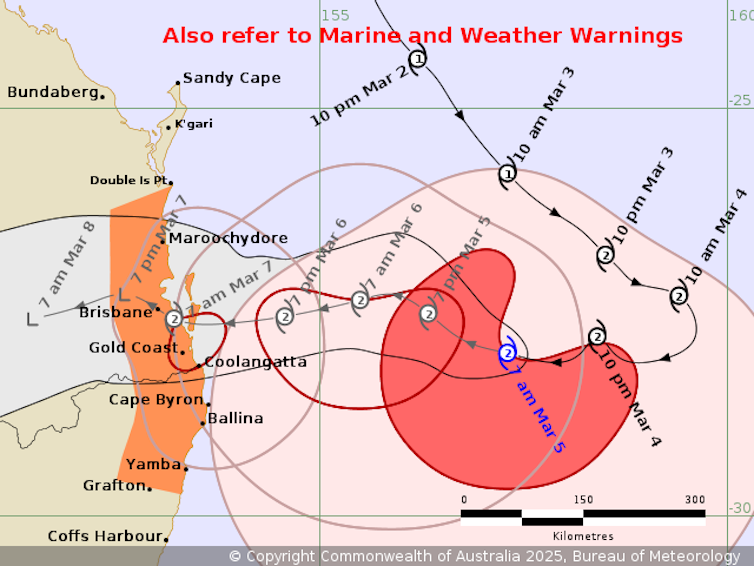
The bureau released the below map on Wednesday morning. It shows the bureau’s best estimate of the cyclone’s future movement and intensity.
The grey zone indicates the range of tracks the cyclone centre may follow. The bureau says winds will almost certainly extend to regions outside the rings on this map.
Cyclone Alfred tracking map released by the Bureau of Meteorology on Wednesday morning shows it circling of the coast of southeast Queensland.BoM
Why is Alfred so fired up?
Cyclone Alfred has been meandering off Queensland’s coast for almost two weeks. Unusually, it has maintained its cyclonic structure and intensity much further south than is typical.
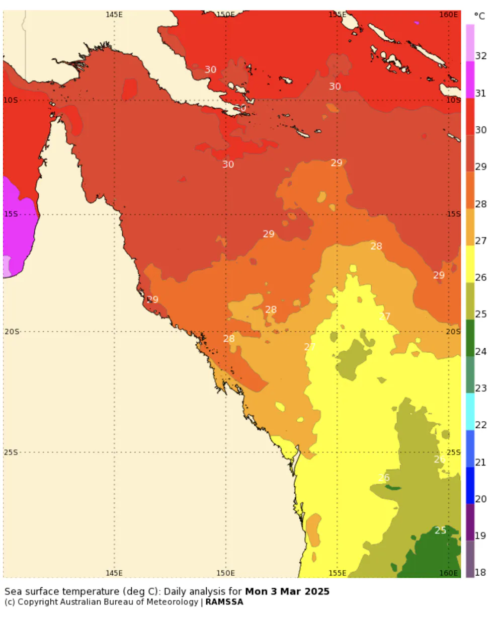
Over the past two days, unique atmospheric and oceanic conditions have allowed Cyclone Alfred to intensify.
It moved towards an area of warmer coastal water (around 27°C), which caused it to strengthen. It also moved into an area of reduced “vertical wind shear” – a variation in wind speed running at right angles to prevailing winds, which often acts to weaken a cyclone.
Image showing high sea surface temperatures which are fuelling the cyclone.BoM
Usually, cyclones in this part of Australian waters may brush the coast, but are soon pulled south or east by an upper trough of cold air and then flicked away into the cooler waters of the Tasman Sea – to an area known as the “cyclone graveyard”.
The current situation is unusual because that upper trough is absent. At the same time, a high pressure system in the Tasman Sea is steering the cyclone towards the coast.
The big question now is whether Alfred reaches category 3 – that is, very destructive winds of 165–224km per hour.
Should the cyclone’s forward motion towards the coast slow, it raises the chances of becoming a category 3 storm. That’s because it would spend more time passing over the warm area of coastal water.
Category 3 winds are likely to cause significant structural damage to some buildings. Brisbane is, to some extent, sheltered from the winds by offshore islands. Other areas, such as the Gold Coast, do not have such protections.
How long will the cyclone last?
As I write, gales are starting to rake the coast – including where I live, on the Sunshine Coast. Conditions will continue to deteriorate this afternoon and into tonight.
The cyclone will bring gale-force winds to a large area of coastline – from Double Island Point in the north to potentially as far south as Coffs Harbour.
By Thursday afternoon, conditions on land and just offshore will be pretty rough. If the cyclone keeps travelling at a constant speed, it will cross the coast in the early hours of Friday morning.
This is less than ideal. It will be dark and people can’t see what’s going on. But there is much affected communities can do to prepare, as outlined here.
For cyclone preparedness and safety advice, go to Get Ready Queensland. For emergency assistance call the State Emergency Service (SES) in NSW or Queensland on 132 500.
A Bureau of Meteorology update on Cyclone Alfred dated March 5.
Steve Turton has previously received funding from the federal government.
This article is republished from The Conversation under a Creative Commons license.
RUGBY Crusaders playmaker James O'Connor will have his ears pricked for any familiar calls from the Reds when he meets his former Super Rugby side for the first time on Sunday in Christchurch More...
BUSINESS The Finance Minister's bidding Air New Zealand's chief executive farewell - who's resigned today More...