|
|
Home >
Weather >
NZ Weather
 National Weather Summary
 |
| Kaitaia |
| Today |
 |
Hi:
Low:
 |
15°
7°
8 |
Partly Cloudy with 8kph SE winds
|
|
|
|
For detailed forecast click here
|
|
 |
Move your mouse pointer
over towns for local
forecasts & click for details |
|
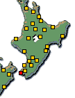 |
 
Click above for North
& South Island Weather |
| Tomorrow |
 |
Hi:
Low:
 |
16°
8°
|
| Fine |
|
|
| Wednesday |
 |
Hi:
Low:
|
16°
5°
|
Few Showers
|
|
|
|
|
| National Short Range Summary |
|
|
Northland to Taumarunui and Taupo, including Bay of Plenty
Mainly fine, but the odd shower about eastern Northland. Areas of frost in sheltered places this morning.
Taranaki, Whanganui and Taihape to Kapiti
Occasional showers, but long fine spells this afternoon.
Wellington, also Gisborne to Wairarapa
Showers.
Nelson, and Marlborough excluding the Kaikoura Coast, also Buller to Fiordland
Fine, with morning frosts.
The Kaikoura Coast and Canterbury
Cloudy periods and showers.
Otago and Southland
Mostly cloudy, with isolated showers, but fine about central Otago. Morning frosts inland.
Chatham Islands
Mostly cloudy with showers. Increasing fine spells from this afternoon.
click here for your national text summary and Long Range Forecast
|
Data is for information only. New Zealand City disclaims all liability or responsibility for any loss or damage that may result from the
action or failure to act by any person in reliance on any information provided herein.
All content © 2025 NZCity Ltd, data © 2025 MetService and other providers.
|
|
|